Property Records let you conduct a quick property deed lookup and land title search without leaving home, giving instant access to real estate ownership records, mortgage lien registry details, and parcel map data. You can pull tax assessor records, review property tax history, and generate a title abstract report that includes cadastral survey information and chain of title documentation. This fast‑track approach saves time for buyers, sellers, and agents who need reliable data now.
Property Records also support thorough property ownership verification by tapping into the recorded deeds archive and land parcel identification tools. Users can explore property transaction history through the county recorder office’s electronic property records or a dedicated property record retrieval service. The platform includes historical property ownership, property boundary records, and real estate public records, plus easy property record request forms, a land ownership database, and a property records online portal. Search fees are transparent, and confidentiality policies protect your data.
How to Search Property Records
Greenville County property records can show the owner listed for a parcel, recorded deeds, assessed values, tax entries, and GIS boundaries. Reviewing these records helps buyers, sellers, agents, and owners check a property before a real estate deal. Individuals can also check sex offenders to verify relevant details. The county’s online search begins at the official Real Property directory listed below. A county search supports due diligence, but it does not replace a title examination by a title company or attorney.
Official Search Portal: https://greenvillecountysc.gov/disclaimer/PublicRecords.aspx?DirURL=RealProperty
Steps to Search
- Open the county’s Real Property directory in your browser. The address above leads to Greenville County’s public records disclaimer page with a Real Property destination, so keep the county domain visible in the address bar. If the page redirects, follow the prompt or link that continues to the property search.
- Read the disclaimer before using the portal. It may explain the county’s record provider, limits on copied records, citation rules, or charges for document images. This step helps you judge the source and avoid treating an informal screen capture as an official record copy.
- Choose the real property search from the county records page. Look for fields that accept an owner name, property address, or map or parcel number. Some portal versions also place property search under a Real Estate, Tax, or Records menu, so check those labels if the first page does not show a search box.
- Enter the strongest identifier available for the property. Use the legal owner name, full situs address, or map number shown on a tax bill, deed, appraisal notice, or survey. For an owner search, test surname-first and first-name variations, then compare any middle initials, suffixes, and punctuation.
- Compare the result rows before opening a property. Match the returned parcel by map or parcel number and situs address rather than by owner name alone. A family member, former owner, business, or similar address can produce several results that appear related at first glance.
- Open the property record and review each tab shown for ownership, assessments, taxes, maps, and recorded documents. Write down the owner name, parcel number, legal description, instrument number, recording date, and any note that says the record is pending, partial, or superseded.
- Open linked deed images for the property and read the recording header. Confirm the grantor, grantee, deed date, recording date, consideration, and legal description. A transaction index supplies a lead, while the recorded image supplies the actual filing.
- Use the county’s stated request process for older documents, bulk data, certified copies, or records that the search does not display. The request form should show any search, copy, certification, or postage charge before payment. Submit personal data only through the county’s listed request channel so its privacy and confidentiality rules apply.
Property Ownership History
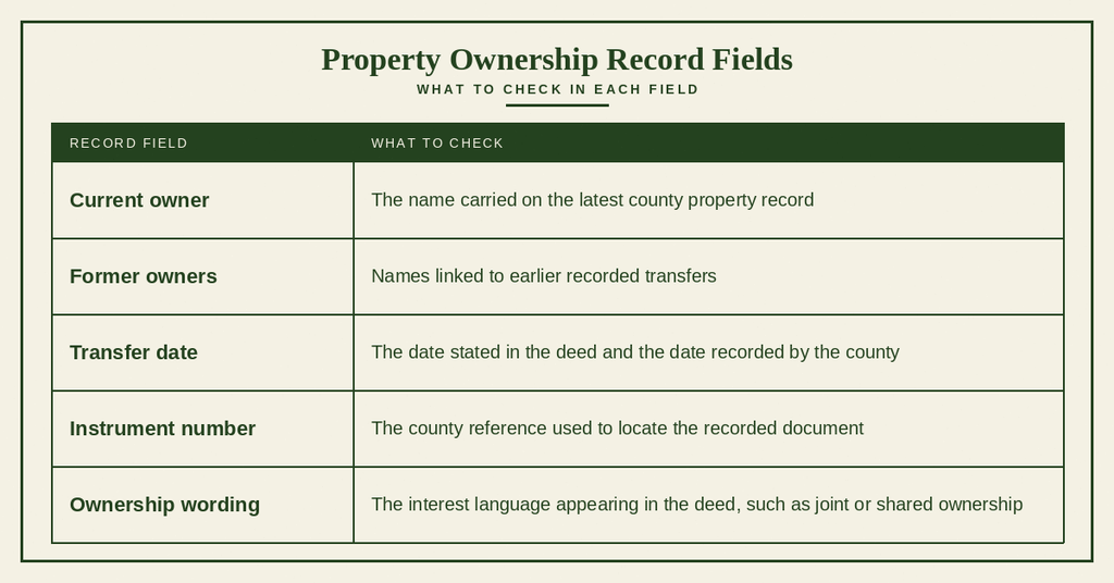
Ownership history connects the names carried on the tax roll with deeds and other instruments recorded by the county. A careful review can reveal the sequence of transfers, the dates tied to each event, and the wording used for joint or shared interests. The goal is not merely to find a name, but to connect that name to the correct parcel and source document.
Current Ownership
Start with the current owner field, then compare it with the grantee named on the most recent deed available for that parcel. A deed can reach the Register of Deeds before the assessor changes the tax roll, which may leave a short gap between recording and tax posting. For a pending sale, ask the closing agent or attorney which instrument has been recorded and whether the assessor has processed it.
Previous Owners
Previous owners appear in the deed sequence as earlier grantors or transferors. Start with the most recent transfer and move backward through each linked instrument, keeping the map number and legal description on your worksheet. The recorded deeds archive can extend the chain farther than a basic ownership screen, which makes it useful for researching property tax history and long-term ownership patterns.
Ownership Transfers
A recorded transfer may reflect a purchase, gift, inheritance, divorce property division, foreclosure, or transfer to a trust. The deed type and its text show the legal action, while an index label may use broader wording. Read the operative language before treating a transfer as a market sale or assuming that every name change came from an arm’s-length transaction.
Ownership Dates
Compare the document date, any effective date stated in the deed, and the county recording date. Recording establishes when the county received and indexed the instrument; it may differ from the date the deed was signed. Sorting the chain by recording date helps reveal gaps, out-of-order entries, or instruments that were corrected after the first filing.
Multiple Owners
Two or more names can appear because the property was conveyed to joint tenants, tenants in common, marital property, a trust, or another shared interest. The assessor’s record may show all names without stating the legal relationship. Read the deed’s ownership clause and, for an estate or trust, identify the role played by each named party before drawing a conclusion about control of the property.
Name Changes in Ownership Records
An owner may appear under a birth name, married name, legal name change, business name, or the name of a trustee or corporate officer. Search the surname first and test first-name, middle-initial, and suffix variants. Deed indexes normally preserve names as recorded, so small spelling differences can divide one owner’s holdings among separate result sets.
Property Transaction History
Property transaction history shows how ownership changed and when the county recorded each event. Deeds can include sales, gifts, transfers after death, court orders, and other conveyances, so the document type matters. A recorded transaction gives dated market context, but it does not by itself prove the present owner’s full legal rights or reveal every claim against the property.
Deed Transfers
A deed is the recorded instrument used to convey an interest in real property. The county’s electronic property records can link a parcel to deed images and related filings, allowing you to trace the chain of title documentation. Look for the deed’s full legal description and any prior reference to another instrument, since those references can connect transfers that are not visible in a simple owner list.
Sale Dates
Three dates may appear for a transaction: the date on the deed, the date the deed became effective, and the date the county recorded it. A closing date may also appear on the tax or transaction entry. Compare all available dates before placing a sale within a tax year or a broader market period, since those dates can fall within different calendar years.
Sale Prices
The deed consideration is the amount written into the transfer instrument and may reflect the purchase price, gift value, court-awarded amount, or other stated consideration. It is not automatically the property’s assessed value or current market value. Private transfers, trades, and property received through settlement can produce a deed price that differs from an arm’s-length sale price.
Grantor and Grantee Information
The grantor is the party giving or conveying the interest, and the grantee is the party receiving it. Match each name with the deed signature and then follow the grantee into the next recorded transfer. This creates a source-based chain rather than a list built only from search-result labels, which matters when trust names, married names, or corporate officers appear.
Recording Details
Recording data records the county’s filing event. Depending on the document and record period, this may include an instrument number, recording date, book and page, or file reference. Save these items because they let the Register of Deeds, a title professional, or your attorney retrieve the same document from the recorded deeds archive without relying on a name-only search.
Historical Transactions
For historical property ownership, place each deed in date order from earliest to latest. A title abstract report is a separate work built from those instruments and their recorded links; an online transaction list alone is not that report. If older books are not indexed online, send the county the parcel number, owner names, date range, and any known book or page reference to narrow the archive request.
Property Tax Information
Tax assessor records track the property value, tax charges, payments, and exemptions used for billing. These records can show how the county treated a parcel over several years, but they do not serve as a deed search. Keep tax entries and recorded ownership documents separate, then compare dates and parcel identifiers when both appear to concern the same property.
Taxable Property Value
Taxable property value is the value used by the assessor for tax calculation after any assessment ratio and applicable exemption. It is not the same as a current appraisal, a deed price, or an estimated resale value. Land and improvements may appear in separate lines, so review each line rather than treating the total shown in the portal as a single market figure.
Property Tax Amounts
Property tax amounts are based on taxable value, the millage applied by each taxing authority, and any exemption or adjustment. The amount billed for one year may change from the next because of reassessment, a millage decision, a corrected account, or an approved appeal. Compare the year and tax status shown beside every amount before using it in a budget or closing calculation.
Tax Payment History
Tax payment history lists each assessment year with charges, credits, payments, and the balance recorded by the assessor. Entries from earlier years can help reveal whether a parcel carried a consistent tax status or underwent major reassessment. A receipt showing payment supports tax compliance, though it does not confirm that every mortgage or other lien was released.
Delinquent Taxes
A delinquent entry means the county record shows an unpaid balance for the stated year. Past-due taxes can lead to collection action or participation in a tax-sale process under county rules, so request a current status from the assessor before assuming the balance is still open. Correct an address or ownership error early because it can affect notices sent to the record owner.
Tax Exemptions and Adjustments
Exemptions and adjustments can reduce the taxable value or the tax charged for a qualifying property. A recorded homestead exemption, assessment appeal, or other adjustment may explain why the billed amount differs from the value shown on the assessment record. You can also consult address lookup to locate official filings. Ask the assessor which year and authority support each adjustment, and keep any approved notice with your property records.
Mortgage Lien Registry Checks
A mortgage or deed of trust is a separate recorded instrument from the tax entry for the parcel. A paid-tax status does not prove that a mortgage lien was released, and a clear tax account does not remove every lien from the title. For property ownership verification, compare recorded deeds, mortgage filings, tax records, and the lien search performed by the closing party.
Property Maps and Parcel Boundaries
Property maps connect a street address and parcel number to a physical location, nearby parcels, and a mapped boundary. GIS tools are useful for orientation and comparison, yet they serve a different purpose than a measured land survey. A small line position or shape on a tax map may not show the exact boundary described in a deed or recorded plat.
GIS Property Maps
GIS Property Maps place tax parcels over a street or aerial base and can display ownership labels, map numbers, addresses, and assessment layers when selected. Use the map to confirm that the result sits in the expected location and to recognize neighboring parcels. Keep the printed or recorded source beneath the map layer, since a browser view can change with each county update.
Parcel Boundaries
Parcel boundaries in a GIS layer represent the county’s tax-mapping geometry. A deed may describe a boundary by metes and bounds, distances, recorded lot dimensions, or references to a plat. When cadastral survey information conflicts with the GIS shape, the survey and recorded description require review by a qualified land surveyor or title professional.
Lot Dimensions
Some parcel maps display lot dimensions or acreage taken from tax and subdivision data. Those figures can help screen a property, but they may be rounded, inherited from an older plat, or measured from a different point than a field survey. A buyer relying on setbacks, fencing, building placement, or total acreage should request the recorded plat or a current survey.
Neighboring Parcels
Neighboring parcels can help identify shared boundaries, common areas, nearby structures, and the map numbers of adjoining land. The GIS display does not decide where a legal boundary falls or prove that a fence follows it. Record the parcel numbers of affected neighbors, then compare them with the recorded survey when access, drainage, encroachment, or fencing is at issue.
Map-Based Property Location
Map-based searches begin with a parcel number, address point, or selected map feature. After locating the parcel, confirm the street name, owner label, and adjacent road network against the written record. Map-based property location is a strong cross-check, especially when a street address appears in several developments or a parcel contains more than one building.
Property Record Verification
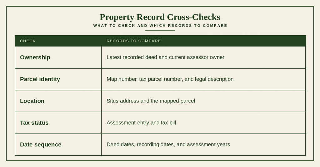
Property ownership verification requires matching records that serve different legal and accounting purposes. A deed shows a conveyed interest, the assessor carries the property under a tax account, and GIS displays the county’s mapped parcel. Use the checks below to connect those records before treating a name or address as confirmed.
Confirming Property Ownership
Begin with the latest recorded deed, identify its grantee, and follow the grantor name backward through earlier instruments. Then compare that chain with the current assessor record. If both point to the same person or entity and the parcel identifiers agree, you have a stronger ownership match than either record can provide by itself.
Matching Parcel Information
Compare the map number, tax parcel number, situs address, and legal description across the deed, tax account, and GIS entry. A number may appear with leading zeros, dashes, or a different label in county systems, so compare the digits and any prefix. The match is strongest when each source points to the same physical parcel and the same ownership event.
Checking Property Address
A property can have a situs address used for assessment, a mailing address used for notices, and a descriptive address copied from an older deed. Compare the street name, directional term, road suffix, unit number, and subdivision name. Do not treat a mailing address change as proof that the parcel moved or that ownership changed.
Comparing Property and Deed Data
Compare the legal description with assessor details for lot, block, subdivision, acreage, and improvements. A mismatch may come from a shortened assessor description, a survey correction, an old subdivision name, or a recording error. Write down the exact wording from each source so the reviewing office can decide which source supports the requested change.
Reviewing Record Dates
Sort recorded deeds by recording date and place assessment entries beside the tax year they cover. The owner change, recording date, assessment effective date, and tax bill date may all differ. A gap between a deed and the assessor update can explain a temporary mismatch, while a mismatch that persists across several cycles deserves a written inquiry.
Identifying Record Discrepancies
Classify each discrepancy before requesting action: missing deed, wrong indexed name, incorrect parcel number, stale tax owner, or address conflict. Compare the source document rather than picking the record that appears most convenient. If the conflict remains, send the Register of Deeds or assessor the parcel number, source image, and a short statement of the conflicting fields.
Correcting Property Records
Correcting property records means fixing the county’s record entry or index without changing the underlying ownership history. The proper office depends on the field at issue. The Register of Deeds handles recorded instruments, while the assessor maintains tax accounts, parcel data, and assessed values. A recorded image remains part of the history even when a later instrument or assessment record corrects a prior entry.
Incorrect Owner Information
An incorrect owner name can exist in the deed index, the assessor’s tax roll, or both. If a transfer instrument exists, provide its recording data and request an index correction from the Register of Deeds. If the deed is recorded but the tax owner remains old, ask the assessor to review the transfer and update the tax account under its procedure.
Incorrect Property Details
Property details may contain a wrong lot, block, subdivision, acreage figure, or improvement description. Cite the recorded deed, plat, or survey that supports the correct wording and identify the affected parcel. This creates a clear basis for review and prevents a correction request from being confused with a request to change ownership through a new deed.
Parcel Number Errors
Parcel number errors can result from a missing prefix, omitted leading zero, transposed digits, or outdated mapping data. Compare the number across the tax bill, GIS parcel, assessor account, and deed legal description. If the written description and map still point to the same land, send both references with the correction request so staff can trace the numbering issue.
Address Errors
An address error may affect where tax notices, legal papers, or inspection requests are sent. Confirm whether the problem concerns the situs address, a subdivision name, a unit number, or the owner’s mailing address. You can also explore 24 hour booking through available county records. Provide the approved address source and state that the request changes the record entry rather than asking staff to infer a new location.
Supporting Documentation
A correction packet should contain the parcel number, current owner name, record being questioned, precise correction requested, and source that proves the correct entry. Useful items include a recorded deed, instrument number, tax bill, assessor notice, recorded plat, and survey. Include only the pages needed for review, mark each copy as a copy, and keep the original documents in your file.
Property Record Correction Requests
Use the county’s current property record request form or written correction process for the responsible office. State the error in one clear sentence, attach the supporting record, and ask for written confirmation of the result. Any fee depends on the requested service, so review the form before submission and keep a copy of the dated request with your property records.
Property Record Search Problems
Most search problems come from an identifier mismatch, a name change, an address variation, or a recent recording that has not reached every county system. Work from the strongest parcel identifier before changing search methods. If the portal and supporting documents still conflict, record the exact source of each entry and request an office review rather than guessing.
Property Not Found
If a property does not appear, confirm that it lies within Greenville County and try another identifier. Remove apartment or unit text, try both the full street name and common road suffix, and preserve leading zeros in a map number. A parcel created after the last database posting may also require confirmation from the county office.
Owner Name Does Not Match
An owner-name mismatch can follow a marriage, divorce, name change, trust transfer, or corporate filing. Search by map number to locate the parcel, then read the owner line and the most recent deed’s grantee. If the records list several similar names, compare middle initials, suffixes, and the role of any trustee or business entity.
Parcel Number Does Not Match
Confirm that the number came from the same record system as the search form. A county map may use a map number, while a tax account or document may use a tax parcel identifier. Remove visual separators only after preserving the original, and compare every digit and prefix. An unchanged legal description can help connect a reformatted number to the correct parcel.
Address Search Failure
Try the address without apartment text, then test common variations for a directional term or road suffix. Old deed descriptions may use a historic road name that differs from the current situs address. Searching by parcel number is often faster than producing several address combinations, especially in subdivisions with repeated street names.
Recently Transferred Property
A recent transfer may appear in the deed index before the assessor’s owner record changes. Check the recording date, grantor, grantee, and instrument status, then ask the closing party whether the deed has been fully recorded and accepted for assessment. Do not treat the former owner shown on the tax roll as proof that the transfer failed.
Historical Record Unavailable
If an older deed is not shown online, identify the approximate transfer year, owner names, parcel, and possible book or page reference. Older record books may be indexed differently or held outside the current electronic property records. Submit a request for the historical instrument and ask the county to search its recorded deeds archive and related index.
Conflicting Property Information
Place the latest deed, assessor entry, tax account, and GIS parcel side by side. Check names, identifiers, address, dates, and legal description, then decide which conflict affects title, tax billing, or mapping. For an unresolved difference, send each conflicting value with its source to the responsible office and request a written finding before relying on the entry.
Contact Information
- Address: 301 University Ridge, Suite S-1000 Greenville, SC 29601
- Phone: (864) 467-7300
- Office hours: Monday to Friday, 8:30 AM–5:00 PM
Frequently Asked Questions
Below are quick answers for common questions about accessing Property Records in Greenville County.
How can I find Greenville property records online?
Visit the official Greenville County Real Property portal at the web address provided. Enter the parcel number, owner name, or address in the search field. The system returns the recorded deed, assessed value, tax entries, and GIS boundary map. Results can be viewed on screen or printed as PDF. If you need copies of official documents, use the “record request” link to order certified copies. The portal is open during normal office hours, and assistance is available by calling the county recorder office.
What info appears in a property deed lookup?
A property deed lookup shows the current legal owner, a description of the land, and any recorded restrictions. It also lists the date of the deed, the grantor and grantee names, and any prior owners recorded in the chain of title. The entry may include a reference to a mortgage lien or easement. Tax assessor records linked to the deed display the latest assessed value and tax history. All data is drawn from the recorded deeds archive maintained by the county recorder office.
Are there fees for a land title search in Greenville?
Yes, the county charges a small fee for each title search request. The amount depends on the type of record and the number of pages printed. Fees are listed on the property record request forms available on the online portal. Payments can be made by credit card, check, or cash at the recorder office. If you need a full title abstract report, the cost will be higher because it includes a compilation of all ownership transfers and lien filings.
How do I check mortgage liens on a parcel?
Start by entering the parcel number in the online search tool. The system displays any recorded mortgage lien entries in the mortgage lien registry. Each entry shows the lender name, loan amount, recording date, and lien status. For detailed information, request a copy of the lien document through the county recorder office. The copy includes the full terms of the loan and any subsequent releases. Contact the office during business hours if you have questions about interpreting the lien data.
Where to request historic property ownership documents?
Historic ownership documents are stored in the recorded deeds archive. Submit a request using the property record request forms on the county’s website. Indicate the parcel number and the years you need. The archive staff will locate the original deeds, chain of title documentation, and any associated cadastral survey information. Expect a processing time of a few business days. You can receive the documents by mail or pick them up at the recorder office located at 301 University Ridge, Suite S‑1000.